Normandie University, UNIHAVRE, UNIROUEN, INSA Rouen, LITIS, Le Havre, France
Goal: Post-disaster operations are a challenging issue, which becomes very complex due to the high density of population in urban areas. Thus, efficient relief operations are very relevant in attenuating the impacts of disasters on the population. For this purpose, optimizing post disaster operations plays a key role, and such issues are focused on this contribution.
Design / Methodology / Approach: Optimization problems appearing in the aftermath of disasters, related to accessibility, distribution and facility location are summarized. They were addressed using real data and the core of such problems was identified in a bottom-up approach, by analyzing the situation on the ground.
Results: Examples of results are presented by means of maps with decision support information. A case study on an addressed location problem is described for the 2015 Kathmandu earthquake. In addition, new trends and opportunities are pointed out, taking into account technological tools, the endogenous characteristics of disasters and emerging applications.
Limitations of the investigation: Regarding the Kathmandu case study, two issues are left for future studies: the uncertain data associated with the affected population and the elasticity of demands.
Practical implications: The data treatment to produce inputs for the algorithms and suitable outputs for the relief teams highlight a collective effort and a real opportunity to use the results practically for humanitarian logistics.
Originality / Value: The optimization models were progressively approached to the situation on the ground, which permits us to identify difficult aspects of the problems, while remaining pragmatic enough to solve real issues.
keywords: Post-disaster relief; Optimization problems; Large-scale disasters; Humanitarian logistics.
Natural disasters seriously affect populations, the environment, and urban infrastructures, causing deaths, migration, and economic loss. According to the International Disaster Database (EM-DAT, 2018) records, in 2018, 281 natural disasters were reported, affecting over 60 million people around the world, with 10,733 deaths. While in 2017, a total of 335 natural disasters were reported, impacting over 95.6 million people, with 9,697 deaths and a cost of, approximately, US $335 billion. This scenario becomes even more critical due to the high density of population in urban areas. Currently 3.4 billion people occupy 10% of the earth’s surface (CRED and UNISDR, 2019).
In such context, the scientific community investigates ways to attenuate the effects of disasters on the population in the so-called phases of disasters: Preparedness, Response, and Recovery. In spite of that, as highlighted in Kunz et al. (2017), the application of results to practice is not proportional to the number of published studies. There are two main reasons for that: access to data and the numerous superfluous aspects (constraints, objectives, etc.) added to the models. This makes it difficult to extract the core of the problems. The author’s research on humanitarian logistics tries to fill these gaps. First, the problems have been defined in a bottom-up approach with members of the International Charter Space and Major Disasters (ICSMD, 2014). The input from ICSMD expertise over almost 20 years helps the contextualization. Therefore, it was possible to identify the core of mathematical models and, subsequently, to design dedicated optimization algorithms. Second, it allows us to access real data, not only past data, but within hours of a major disaster, as was the case of the Kathmandu earthquake that hit Nepal in 2015.
This study summarizes the main results of my contributions on solving optimization problems for post-disaster operations. Among the problems studied, scheduling, vehicle routing, and facility location problems have been investigated, using real data (see Section 2). In addition, the case study of the Kathmandu earthquake in 2015, where emphasis was put on locating field hospitals, is detailed. In the following, the focus is put on providing new trends and opportunities on humanitarian logistics in a combinatorial optimization perspective, considering: technological tools, the endogenous characteristics in disaster situations, and new applications (see Section 3). Some concluding remarks are presented in Section 4.
Some well-known optimization problems are found in the phases of disasters, such as assessment and inventory in the “Preparedness phase”; location, accessibility and distribution for the “Response phase”; and power system restoration and economic recovery for the “Recovery phase” (Leiras et al., 2014). Most of the time, optimization models in disaster relief are subject to many complex issues, such as uncertain data, vague or imprecise information, conflicting decisions, multi-criteria decisions, and limited human, material and financial resources. In addition, post-disaster operations require reactivity and a special attention to human and social issues. When thinking about designing mathematical models for optimization problems in this context, four basic characteristics should be considered:
Note that the way optimization models are designed depends on all such issues, since the operations may change according to the characteristics sought. For instance, the type of disasters implies different ways of performing operations. The time-scale and the optimization levels impose the use of different methods, such as fast and efficient heuristics for emergencies (operational level), while more time-consuming methods can be used for other time-scales (tactical and strategic levels). One may note that taking all of these issues into account may be very difficult. However, some aspects can be addressed “just in time” after major disasters, using real data.
In the past five years, I have studied mathematical models and dedicated heuristics for three classes of problems: accessibility, distribution, and facility location. The methods were not part of an application or a support decision-making system, since it seemed more acceptable for the operators, and simpler as a first approach, to communicate these outputs using maps with decision support information.
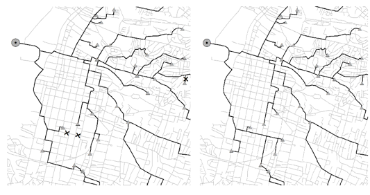
Two accessibility problems were studied: The Road Network Accessibility Problem (RNAP) and The Work Troops Scheduling Problem (WSP) (Sakuraba et al., 2016a, 2016b). RNAP appears in emergencies and the idea is to identify paths quickly from starting points to target areas in the city. Our first contribution was to model this problem as a flow problem and then to prove that it can be solved by polynomial time algorithms such as Dijkstra (1959). In spite of that, obtaining the initial state of the network accessibility is very relevant. The WSP is an NP-hard problem and consists of scheduling work-troops to clean debris and to improve the overall accessibility of the urban networks. The idea is to assign work-troops to unpassable routes, and to update the state of the urban network once the corresponding routes are passable. Both problems were handled on a large-scale, and tested over instances from Port-au-Prince, Haïti, using ICSMD data treatment for the earthquake of 2010. The graph of Port-au-Prince contains 16,660 vertices, 19,866 routes, and more than 500 blocked roads. This is an enormous scheduling problem! Thus, particular attention was given to the algorithm complexity, and the implementations were optimized with sophisticated data structures. Some new avenues of research on these topics are introduced in Santos (2018). An example of outputs in maps with decision support information for this study is given in Figure 1. The left part of Figure 1 illustrates the state of the network with two cross points to indicate blockages. The right part shows the paths after removing these blockages.
Figure 1. Example of accessibility maps.
Source: OLIC Project.
After obtaining the initial network state and addressing the WSP, the next step was to study distribution problems. We decided to separate the distribution into two major problems: the macro distribution (Santos, 2016) and the last-mile distribution (Penna et al., 2018). This was done since we realized that these two levels are clearly distinguished: the operations for both are done independently, with no coordination protocol between humanitarian operators. Macro distribution consists of defining routes to deliver supplies from big hubs (e.g. port and airport) to intermediate depots close to the population (delivery points). The second level corresponds to the chaotic stage of distribution, referred to as last-mile distribution. It consists of delivering supplies from depots to the affected population (delivery points). Both problems are modeled as rich Vehicle Routing problems (VRP). VRP are difficult discrete optimization problems (a route with 69 demand points implies 69! 1099 possible combinations); however, it can provide relevant gains compared to a human response (km, time, number of vehicles, CO2 emissions). They have been widely studied in the literature since the pioneer work of Dantzig and Ramser (1959).
Our developments for distribution problems took into account state of the art developments in the literature for VRP, which is somewhat neglected in the literature dedicated to humanitarian logistics (Penna et al., 2018). Thus, these methods were compared to the best algorithms found in the VRP literature (Salhi and Sari, 1997; Salhi et al., 2014; Vidal et al., 2014). The outputs generated were also depicted in maps with decision information such as the one illustrated in Figure 2. It was inspired by metro maps, and one important remark is that routes are not designed as in VRP. In general, on normal days routes have petal shapes, while here routes make use of the same paths to deliver and to return to depots due to some blocked roads.
Figure 2. Maps for last-mile distribution using Port-au-Prince graph of the 2010 earthquake.
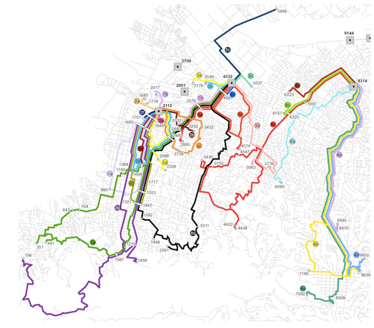
Source: OLIC Project.
On April 25, 2015, an earthquake of magnitude 7.8 on the Richter scale struck Kathmandu, Nepal. This was followed by more than 450 aftershocks over 1 month. The impact caused about 9,000 deaths and 22,000 injuries, and damaged historic monuments as well as infrastructures. Figure 3 depicts the epicenter of this event.
Figure 3. Epicenter of the Kathmandu earthquake in 2015
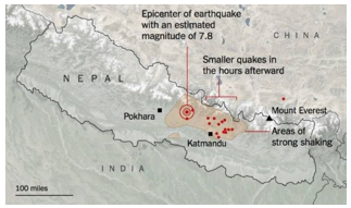
Source: Vaishya et al., 2015
In this context, the problem of locating field hospitals was studied some hours after the disaster. A field hospital is a temporary medical unit composed of tent, staff, medical and logistics equipment. Its mission is, for example, to provide first aid, need assessment and triage. The hypothesis of this study was that a field hospital would provide aid to simple-to-moderate cases and send the most serious ones to hospitals.
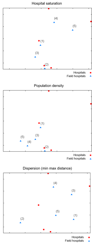
We accessed the following data: an estimation of population in the damaged areas, 707 points where people were assembled, 13 potential locations to install field hospitals, and the position and bed capacity of five hospitals in the city. The biggest one is the Kathmandu medical college and teaching hospital with 600 beds.
Figure 4. Kathmandu hospitals position and potential points to install field hospitals
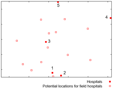
Legend: (1) Patan Hospital, (2) B&B hospital, (3) Bir hospital, (4) Kathmandu medical college, (5) Grande International Hospital.
In terms of optimization, this problem corresponds to a facility location problem. This kind of problem has been studied for the past 150 years (Sylvester, 1857). However, studies in crisis management for frequent emergencies appear in the 1980s: fire, road traffic accidents, floods, etc. An interesting survey on the topic is found in Nahleh et al. (2013). According to the author’s knowledge, the first studies for major disasters appear in Jia et al. (2005), followed by the studies of Jia et al. (2007), and Huang et al. (2010).
For the Kathmandu case study, three optimization criteria were considered:
Attenuate tensions due to the lack of healthcare aid. This criterion was mathematically translated by a hospital saturation criterion, where saturation is defined as a rate of the affected population around a hospital divided by the hospital capacity.
Attenuate population moves. For this purpose, field hospitals are allocated to the areas with the highest population density. It may be noted that this criterion differs from the first one since the hospital capacities are not taken into account.
Dispersion of healthcare aid units in the region. In this case, field hospitals are allocated in such a way that the maximum distance of affected areas to a healthcare aid unit (hospital or field hospital) is minimized.
Deterministic heuristic algorithms were applied, using of the aforementioned criteria independently. The number of field hospitals is set to five. For the first criterion, the idea is to assign a field hospital to the location with the highest hospital saturation rate, and this is repeated until all units are assigned. In the second criterion, field hospitals are assigned to available positions with the highest population density. Using the third criterion, field hospitals are allocated, one by one, in the position that minimizes the maximum distance between the affected areas and a healthcare aid unit.
The results are depicted in Figure 5 and it should be emphasized that they were obtained 48 hours after the disaster. The numbers in brackets close to a triangle indicate the order the algorithm decided to assign a field hospital. The results show that the chosen criterion impacts the results. The first optimization criterion is interesting to support hospitals and accomplish patient triage. The second is more important in emergencies to avoid congestion due to massive movement of population. The last one could be interesting over a longer time-scale. Since field hospitals are temporary units, they can change place according to the overall time-scale of a disaster (days, weeks, and sometimes months after the event).
This work allows us to rethink complex points not treated in 2015. In particular, the fact that affected populations are uncertain and that people can move. Moreover, the decision to place a field hospital makes the corresponding location more attractive. This generates a kind of complex phenomena, usually called the elastic effect, i.e. the more attractive a location becomes, the more people come and the lower the quality of the service is.
Other questions raised are: (i) do people act rationally in a crisis? (ii) do people look for the nearest medical unit or hospital? The answers to these questions can modify the perception of the optimization criteria. We have been working on such points, especially on the population dynamics by means of robust optimization. Even if the initial location problem addressed is quite simple, as well as the methods developed, this study allows us to perceive the core of the problem, and identifying the complex and relevant points to be addressed.
Figure 5. Solutions using the three criteria optimized independently
As previously mentioned, several aspects can already be treated in the aftermath of disasters using real data, and international efforts started around the world, such as EM-DAT and ICSMD. In this context, new opportunities appear, especially due to technological tools that can help in relief operations, the ability to address some endogenous characteristics inherent to disaster relief, and emerging applications.
Up-to-date technological tools, such as aerial drones, information and communication technologies (mobile phones, social networks) and big data, can be applied to improve relief operations. Drones can be used, among other things, to monitor areas in order to detect population moves, points of congestion, unknown impacts and to deliver supplies in difficult areas. Naturally, the use of drones implies revising the optimization models to include the routes of drones, handle their limited flight time and sensors with limited footprint. They can be integrated into:
The study of Otto et al. (2018) surveys more than 200 articles on optimization approaches to civil applications of unmanned aerial vehicles (aerial drones). In particular, different path patterns are presented in order to define ways of covering a target area. This is a key point in large-scale disaster relief since in such events it will be probably not possible to have a full coverage, even using drones. Thus, there is room for investigating strategies to deploy aerial drones. Integrating aerial drones with vehicles is also a promising direction of research, especially in some types of large-scale disasters, such as earthquakes, fire, and mudslides. In the contribution of Poikonen et al. (2017), travelling salesman and vehicle routing optimization models are basically analyzed, using aerial drones for commercial applications.
In the past ten years, Information and Communication Technologies (ICT) have been identified as a potential tool to support and strengthen disaster relief in issues such as communication and coordination. In particular, they can generate silent alarms in case of terrorism, locate people, and detect new and unexpected events, among other contributions. An interesting entry point to this topic is Harvard Humanitarian Initiative (HHI, 2011). Nowadays, the number of mobile phones in the world has substantially increased, covering more than 65% of the world population. In addition, social networks have become strong communication tools. For such purposes, giant internet companies, such as Google (e.g. Disaster Alert, Google Person Finder) and Facebook (e.g. Disaster response on Facebook) have invested in the topic, and an open source platform, such as Ushahidi has also emerged.
In terms of optimization problems, several opportunities involving ICT are still open, and according to this author’s opinion, it is worthwhile and relevant to investigate the mathematical models and optimization problems, without going directly to the development of an application. One central idea behind this thought is that ICT can be a strong communication and coordination tool in the case of disasters, providing it is well used. The mathematical and optimization models do not guarantee that; however, they can define limits and keep a reliable core for the problems. The optimization problems can rely on coverage models, matching similar events to try to define information reliability, partitioning data to extract what is relevant and generating knowledge. This latter point can be seen as information retrieval on big data, for which supervised (linear and non-linear regression, supervised classification, etc.) or non-supervised (k-means, DBSCAN, etc.) algorithms could be applied. Note that reliability is a key point in the mass of data generated in the case of emergencies. In network design, the surcharge of some services (e.g. SMS) can also be modeled by optimization problems to attenuate congestion.
There are two interesting endogenous characteristics of disaster relief with a strong potential for new developments and that could reshape optimization models. The first one relies on population dynamics (people movements, massive migration, the identification of groups and dangerous individual behavior, etc.). This endogenous characteristic of disasters relief requires knowledge from different areas (sociology, psychology, local culture, mathematics, optimization, simulation, etc.), and its mathematical characterization is, as understood by this author, still a big challenge.
A few studies in the literature focus on this topic in such a way that results could be coupled with optimization models. The strategies mentioned below are interesting ways of seeing the population dynamic, and some entry point articles are provided. For instance, Lu et al. (2012) discuss what is predictable and less predictable in terms of population moves after earthquakes. The authors indicate that hurry and disorder suggest that people’s moves would be less predictable. The contribution of Wang et al. (2015) describes a technique to define the new population distribution after a major disaster. This technique was used in some of the author’s works (Penna et al, 2018; Sakuraba et al., 2016a, 2016b) to obtain a picture of the points where people got together after earthquakes. Bengtsson et al. (2011) and González et al. (2008) investigate people’s trajectories by using mobile phones. Another way to handle the population dynamics is using simulation and agent-based systems. The authors in Pan et al. (2007) propose a framework in case of evacuations, while Kniveton et al. (2011) investigate the flow migration due to climate changes with a case study on Burkina Faso. These studies use agent-based systems. Finally, some authors addressed the population dynamics as a different way of distributing supplies according to the type of disasters (Duhamel et al., 2016).
It is a fact that people move and migrate in the aftermath of catastrophes, and this impacts decisions and, in consequence, the optimization models. Whenever a prediction can be made to design the population dynamics, optimization models will produce more accurate solutions. Another possibility consists of integrating learning mechanisms into the optimization process, or even tracking trajectories in real-time and anticipating future decisions. All these research directions have the merit of being investigated by the scientific community.
The second endogenous characteristic of disaster affecting the optimization models is uncertain parameters, e.g. imprecise or partial information of the situation on the ground. Stochastic programming, robust optimization, fuzzy logic, and Markov decision process are examples of methods applied in the literature for optimization under uncertainty. Stochastic programming is one of the most frequently applied methods for disaster management, surveyed in Hoyos et al. (2015) and Grass and Fischer (2016). An interesting review covering several parameters and methods is found in Liberatore et al. (2013).
Parameters such as demand, number of population affected and time to reach target points in a city are often uncertain in emergencies. The author’s concerns in terms of some studies presented in the literature dedicated to disaster relief optimization problems with uncertainties is the lack of a progressive treatment of objective functions, constraints, and uncertain parameters. More progressive analysis could result in insights and identification of the difficult parts of the problems. In addition, it could also be interesting to evaluate the difficulty of approaching a probability law for uncertain parameters in emergencies. I believe robust optimization could be investigated more thoroughly in such contexts, since it does not require an a priori data treatment, and it can provide solutions that avoid the worst-case scenario.
Crossing technological tools with the endogenous characteristics of disasters opens several avenues of research. Several applications have emerged around the world. In Brazil, the mudslide in Mariana in 2015 and in Brumadinho in 2019 caused deaths and important ecological impact with millions of cubic meters of mining waste flowing through agriculture areas and rivers. Such kinds of disasters could be better investigated in terms of optimization problems in the preparedness and response phases. In particular, fast evacuation plans can be prepared in the target areas, the rescue of people and animals, the allocation of strategic points for monitoring, and the positioning of barriers, among others.
Another problem very common in Brazil is the propagation of sickness by a mosquito like such as Aedes aegypti. Some studies investigate the population dynamics of the mosquito and propose optimization models to install barriers (chemical, physical, genetic or biologic) (Florentino et al., 2018), or even define control clustering, as in Negreiros et al. (2008). The type of barriers will affect the mathematical models and is important to reduce the propagation of disease.
Generally, around the world, two topics of great interest involve terrorist attacks like bomb attacks, which require an effort in the preparedness and response phases. In the case of biological or chemical attacks, bombs and nuclear accidents, location and distribution problems arise for vaccination and drug delivery. The second topic of great interest involves the flow of migration due to climate changes, wars, refugees, and economic refugees. The distribution of population, understanding the migration flow, and locating humanitarian help are among the interesting topics to be studied in terms of optimization.
Results for some interesting optimization problems addressed in large-scale disasters have been summarized. The models were created with a bottom-up approach, i.e. the core of the problems was designed in partnership with ICSMD members and tested using realistic data. Maps with decision support information were generated, proving an interesting way to communicate with rescue teams. One contribution of this study is the description of the Kathmandu case study on locating field hospitals. Complex issues were also pointed out.
Another contribution of this study is the presentation of new perspectives for future research on optimization problems in disaster relief operations. Technological tools, endogenous characteristics and emerging applications were discussed in the hope they will inspire young researchers on these topics. Last but not least, it is very important to provide models that will approach the situation on the ground progressively, which allows the difficult aspects of the problems to be identified, while remaining pragmatic enough to solve real problems.
Bengtsson, L. et al. (2011), “Improved Response to Disasters and Outbreaks by Tracking Population Movements with Mobile Phone Network Data: A Post-Earthquake Geospatial Study in Haiti”, PLOS Medicine, Vol. 8, No. 8, e1001083.
Centre for Research on the Epidemiology of Disasters – CRED and United Nations International Strategy for Disaster Reduction – UNISDR (2019), 2018 Review of Disaster Events, Supplementary information, available from: https://www.cred.be/2018-review-disaster-events (access Aug 10, 2018).
Dantzig, G. B. and Ramser, J. H (1959), “The truck dispatching problem”, Management Science, Vol. 6, No. 1, pp. 80–91.
Dijkstra, E. W. (1959), “A note on two problems in connexion with graphs”, Numerische Mathematik, Vol. 1, No. 1, pp. 269–271.
Duhamel, C. et al. (2016), “Connecting a population dynamic model with a multi-period location-allocation problem for post-disaster relief operations”, Annals of Operations Research, Special issue OR Confronting Crisis, Vol. 247, No. 2, pp. 693–713.
International Disaster Database - EM-DAT (2018), available from: https://www.emdat.be/publications (access Aug 10, 2018).
Florentino, H. O. et al. (2018), “Algoritmo de busca em vizinhança variável para determinação de controle otimizado para a população de Aedes aegypti”, Proceeding Series of the Brazilian Society of Computational and Applied Mathematics, Vol. 6, No. 1.
González, M. C. et al. (2008), “Understanding individual human mobility patterns”, Nature, Vol. 453, pp. 779–782.
Grass, E. and Fischer, K. (2016), “Two-stage stochastic programming in disaster management: A literature survey”, Surveys in Operations Research and Management Science, Vol. 21, No. 2, pp. 85-100.
Harvard Humanitarian Initiative - HHI (2011), Disaster Relief 2.0: The future of information sharing in humanitarian emergencies. HHI; United Nations Foundation; OCHA; The Vodafone Foundation, Washington, DC, pp. 1-72.
Hoyos, M. C. et al. (2015), “OR models with stochastic components in disaster operations management: A literature survey”, Computers & Industrial Engineering, Vol. 82, pp. 183-197.
Huang, R. et al. (2010), “Facility location for large-scale emergencies”, Annals of Operations Research, Vol. 181, No. 1, pp. 271–286.
International Charter Space and Major Disasters - ICSMD (2014), available from: https://www.disasterscharter.org (access Aug 10, 2018).
Jia, H. et al. (2005), “A modeling framework for facility location of medical services for large-scale emergencies”, IIE Transactions on Homeland Security, Vol. 39, No. 1, pp. 41–55.
Jia, H. et al. (2007), “Solution approaches for facility location of medical supplies for large-scale emergencies. Computers and Industrial Engineering”, Vol. 52, No. 2, pp. 257–276.
Kniveton, O. et al. (2011), “Agent-based model simulations of future changes in migration flows for Burkina Faso”, Global Environmental Change, Vol. 21, No. 1, pp. S34-S40.
Kunz N. et al. (2017), “Relevance of humanitarian logistics research: best practices and way forward”, International Journal of Operations & Production Management, Vol. 37, No. 11, pp. 1585-1599.
Leiras, A. et al. (2014), “Literature review of humanitarian logistics research: Trends and challenges”, Journal of Humanitarian Logistics and Supply Chain Management, Vol. 4, No. 1, pp. 95–130.
Liberatore, F. et al. (2013), “Uncertainty in Humanitarian Logistics for Disaster Management. A Review”, Decision Aid Models for Disaster Management and Emergencies, Vol. 7, pp. 45-74.
Lu X. et al. (2012), “Predictability of population displacement”, Proceedings of the National Academy of Sciences, Vol. 109, No. 29, pp. 11576-11581.
Nahleh Y. A. et al. (2013), “Facility Location Problem in Emergency Logistic”, International Journal of Mechanical, Industrial Science and Engineering, Vol. 7, No. 10, pp. 1038-1043.
Negreiros, M. J. et al. (2008), “Integração de sistemas computacionais e modelos logísticos de otimização para prevenção e combate à dengue”, Pesquisa Operacional, Vol.28, No.1, p. 1-27.
Otto, A. et al. (2018), “Optimization approaches for civil applications of unmanned aerial vehicles (UAVs) or aerial drones: A survey”, Networks, Vol. 72, No. 4, pp. 411-458.
Pan, X. et al. (2007), “A multi-agent based framework for the simulation of human and social behaviors during emergency evacuations”, AI & Society, Vol. 22, No. 2, pp. 113–132.
Penna P. H. V. et al. (2018), “Vehicle routing problems for last mile distribution after major disaster”, Journal of the Operational Research Society, Vol. 69, No. 8, pp. 1254–1268.
Poikonen S. et al. (2017), “The vehicle routing problem with drones: Extended models and connections”, Networks, Vol. 70, No. 1, pp. 34-43.
Sakuraba, C. S. et al. (2016a), “Road network emergency accessibility planning after a major earthquake”, EURO Journal on Computational Optimization, Vol. 4, No. 3, pp. 381–402.
Sakuraba, C. S. et al. (2016b), “Work-troop scheduling for road network accessibility after a major earthquake”, Electronic Notes in Discrete Mathematics, Vol. 52, pp. 317–324.
Salhi, S. and Sari, M. (1997), “A multi-level composite heuristic for the multi-depot vehicle fleet mix problem”, European Journal of Operational Research, Vol. 103, No. 1, pp. 95–112.
Salhi, S. et al. (2014), “The multi-depot vehicle routing problem with heterogeneous vehicle fleet: Formulation and a variable neighborhood search implementation”, Computers & Operations Research, Vol. 52, PartB, pp. 315–325.
Santos, A. C. (2016), “Shared transportation for macro-distribution in post-disaster relief”, In: 9th Triennial Symposium on Transportation Analysis (TRISTAN), Oranjestad, Aruba (4p.)
Santos, A. C. (2018), “Advances and new trends on network accessibility and reconstruction after major earthquakes”, In: Kovács, G. et al. (Eds.), The Palgrave Handbook of Humanitarian Logistics and Supply Chain Management, Palgrave Macmillan, pp. 547-565.
Sylvester, J. J. (1857), “A Question in the Geometry of Situation”, Quarterly Journal of Pure and Applied Mathematics, Vol. 1, pp. 79.
Vaishya, R. et al. (2015), “Surgical Management of Musculoskeletal Injuries after 2015 Nepal Earthquake: Our Experience”, Cureus, Vol. 7, No. 8, e306. doi:10.7759/cureus.306
Vidal, T. et al. (2014), “Implicit depot assignments and rotations in vehicle routing heuristics”, European Journal of Operational Research, Vol. 237, No. 1, pp. 15–28.
Wang, S. et al. (2015), “Detecting tents to estimate the displaced populations for post-disaster relief using high resolution satellite imagery”, International Journal of Applied Earth Observation and Geoinformation, Vol. 36, pp. 87-93.
Received: 06 May 2019
Approved: 13 Apr 2019
DOI: 10.14488/BJOPM.2019.v16.n3.a14
How to cite: Santos, A. C. (2019), “New trends and opportunities in post-disaster relief optimization problems”, Brazilian Journal of Operations & Production Management, Vol. 16, No. 3, pp. 528-536, available from: https://bjopm.emnuvens.com.br/bjopm/article/view/839 (access year month day).